Hi, everyone. One of my favourite parts of any election night's coverage on CNN is 'the big board', specifically when John King goes through a race's results and boldly proclaims "This is where the people are". Also, there is nothing quite like the drama of a statewide race in Missouri where the Republican is 5 or 6 points up, but you can see St. Louis is still out... PART 1 HEREPART 3 HEREPART 4 HEREPART 5 HERE
**If you read the earlier entry in this series, the introduction below is identical, so you can just skip to the maps**
PART 1 HEREPART 3 HEREPART 4 HEREPART 5 HERE
Also, please drop by visit for the guys at Stochastic Democacy It looks like I'll be doing some live-blogging over there during Election Night, and they're looking like having a really cool system for calling elections that any numbers buff should check out.
However, other than the basics of 'Democrats live more in cities', it's tough to really get a sense of how a race is going to unfold based on what's shown on TV, especially when an important race in the Senate, of which there are several, get fairly little attention in the wake of a Presidential call.
So, I decided to try and help out myself, and by posting this, other Daily Kos readers, by calculating, for every county in the country, a partisan voting index. Think of this as the same as a regular PVI, only at a county level, relative to the overall state result, rather than at the CD-level relative to the overall national result. To do this, I took the results for the Democratic candidate in each county for the last two presidential races and the last two senate races and calculated by how much they differed from the overall state result for the Democrat in the same race.
For example:
2006 VA Senate - Statewide, Webb 49.6% - Rappahannock County, Webb 51.6%, for a rating of +2.0%
By averaging the results from these four races, weighting for the more recent, and weighting the Presidential race over the Senate races a little, I calculated each county's Blarghman County Voting Index (BCVI).
What does this mean, you ask? Well, basically, what it means is that as results come in, you can look at the BCVI values, or more appropriately, the maps I have created that show them, and figure out if the results yet to come favour the Democrat or the Republican. Also, they can give you an early idea of how a candidate is doing.
As in the example above, consider, Rappahannock County, VA. While it was 2 points more for Webb than the state overall, when the other races are factored in, it is about even with the state average. This is reflected in the fact that John Kerry earned 45.4% in the county, and 45.5% in the state.
So, if Rappahannock reports fairly early on Election Night (purely speculation on my part), and Obama is above 50%, it's a very good sign that he will have a good chance at winning the state. To me, this is fascinating stuff, and can really give a lot of input to avid political viewers like myself and many others here.
So, with just a little further ado, I am going to present some maps, along with some brief discussion, of the first 10 states alphabetically, with the maps shaded by BCVI value.
**IMPORTANT NOTES ABOUT MAPS AND ANALYSIS**
- Remember that these are a voting index, not a vote total. The maps depict how far from a STATE AVERAGE a Democrat is expected to be in a given county.
- These are based on data from past elections, and do not consider changes in turnout pattern in this election, nor demographic shifts since the last election. I don't see any way to realistically model these, so I must unfortunately ignore them.
- The number on each county represents it's percentage of overall state 2004 turnout, to give you a rough idea of, as John King puts it, "Where the people are".
- I don't live in any of these counties, and I never have, I'm a Canadian citizen, who is fascinated with the mathematics, statistics, polling, drama and scope of US elections. So if you have something you know about your area that I've mischaracterized, please let me and others know in the comments, and I'll try and fix it.
- Note, unsurprisingly, the deeper red indicate more Republican areas, with the deepest red indicating a Index value lower than -20. The same is true for deepest blue and Democratic counties above +20. White indicates counties that are plus or minus 2.5 from the state average.
- To see a map bigger, including the numbers at much higher quality, at least in Firefox, right click and select 'View Image'. For IE, I think you have to choose 'Save Image', then view it once you've downloaded it.
- Really, this is #1 again, but you can basically consider these maps as a 50-50 scenario, ie. "what if the Democrat and the Republican tied in state X?". For some blood-red and ocean-blue (what else is deep blue, anyone got anything?) states, these will look strange, if only because we aren't used to seeing maps where a Democrat is anywhere near 50% in, say, Idaho.
First, a quick note on Alaska, which I didn't mention earlier.
ALASKA
Races (538 Average/SSP Rating): President - Safe McCain (O 42.2, M 57.1) Senate - Likely Dem (D 52.1, R 46.0) House - AK-AL, Berkowitz v. Young (Tossup)
While Alaska does have 'voting districts', I have neither maps nor complete data for these, so they will not feature here. However, I would suspect that Begich would pull strong support from Anchorage as a former mayor, and the major Democratic area would be Juneau, the only district that Gore carried in 2000. At the state level, Democrats represent all the districts on the northern west coast, and this may be another Democratic area. However, major news media won't give even this poor level of granularity.
ILLINOIS
This page includes a map of county names
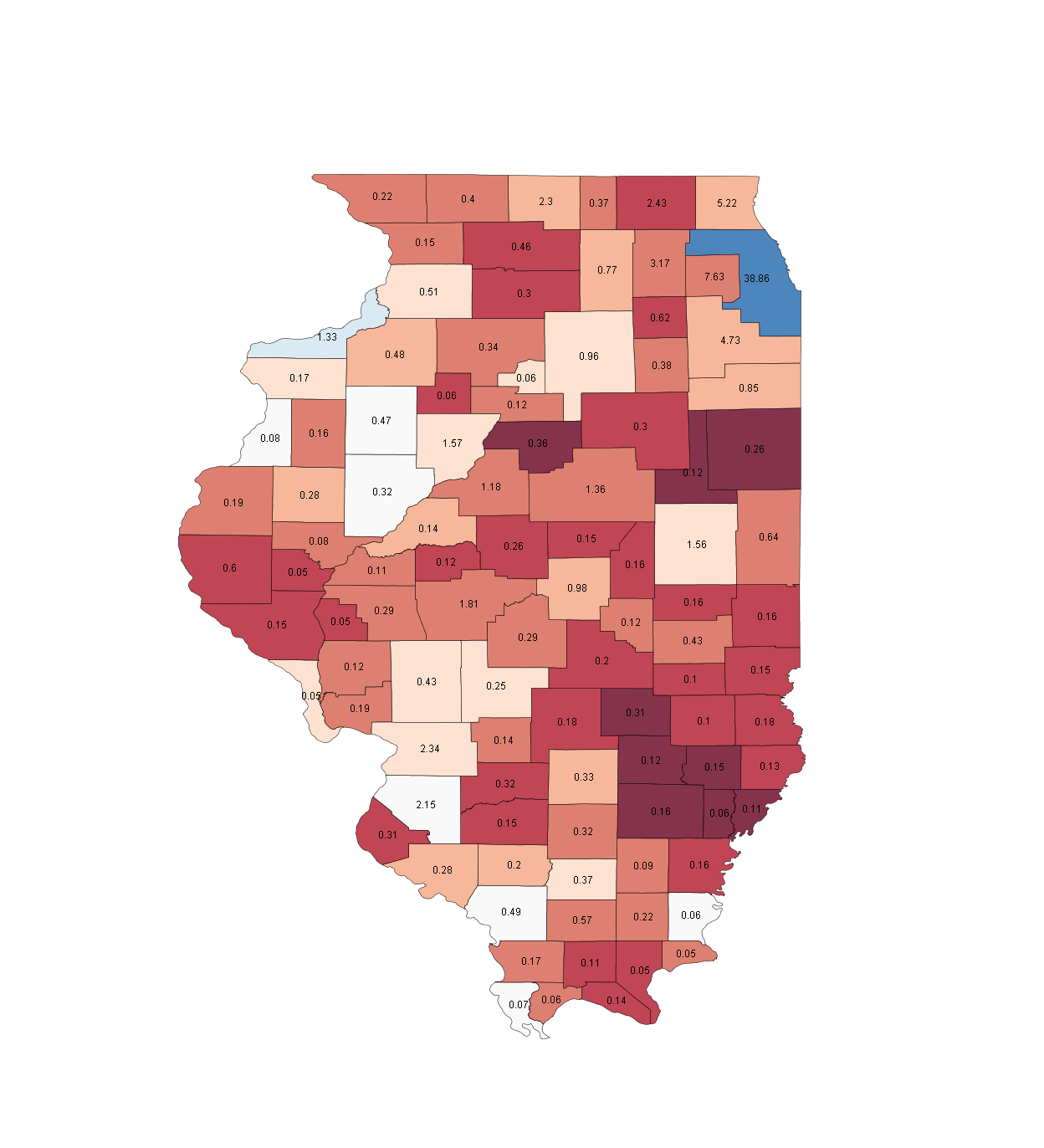
Races (538 Average/SSP Rating): President - Safe Obama (O 60.0, M 38.5) Senate - Safe Democratic (D 63.8, R 33.5) House - IL-10, Seals v. Kirk(i) (Tossup), IL-11 Halvorson v. Ozinga (Likely D), IL-14 Foster(i) v. Oberweis (Likely D)
Just like starting with Alabama last time, if you didn't get the idea from the intro, you should now. This is why a 'blue state' concept is so absurd. This map looks a little silly for a 50-50 race, as there are only two Democratic counties in the state in an instance like that. While it seems absurd, this is a typical John King "win where the people are" state. In her 1998 Senate run, Carol Moseley Braun won just 4 counties, and lost by just 100K votes out of more than 3 million. While Barack Obama won his senate race in 2004 by more than 40 points (!), Alan Keyes still won 10 counties, including the entire deep red section in the southeast.
There was some discussion in the last article comments about using cartograms, and this map is the clearest reason why.
Fortunately for Democrats, there isn't much to say about the two statewide races, which should be quite simple affairs, and both will likely have wide enough margins that the white and pale-red counties will be blue on election night.
Counties to watch: St. Clair County, the white area labelled '2.15' on the southwestern border. is actually part of the St. Louis metro region, and thus gives us not only an insight into Illinois, but also how Missouri is doing for Obama. This was a 55-45 county for Gore and Kerry, and both lost Missouri. Clinton carried it by 20 (with Perot at 7), and won Missouri If Obama has a lead of high double digits here, it will be an easy walk in the state, and Missouri could easily be in play. Obama beat Alan Keyes by 37, how much better will John McCain fare? Maybe my next map will be a Keyes/McCain index.
So with the statewide races pretty dull, our attention should turn to the House races. O2B candidate Dan Seals is in tight in the 10th, a district split between the northern portion of Cook County and the southern of Lake, which has been a near 50-50 Dem-Rep county in the presidential race. High turnout in Cook County from the Obama team can only help Dan Seals. The 11th and 14th are similar looking districts, with the 14th extending west from DuPage county (the red county jutting into blue Cook County), and stopping just short of the blue on the other side. The 11th also stretches across the state, paralleling the 14th but just south of it. Bill Foster did a great job to win the seat in a special election, and should hold it despite some strong republican areas. In the 11th, Debbie Halvorson at least has some pale-red counties, and will probably need to win in Will county just south of Chicago and LaSalle county, the square labelled 0.96, to have a good shot.
Where the people are: Cook County. Almost 40% of votes come from this county, which is larger in population than 29 of the 50 states. Cook County does not even include all of the Chicago metro area, which means that the five counties around Cook contain another quarter of the vote, and that more than 60% of votes will come from the state's northeast corner.
INDIANA
This page includes a map of county names
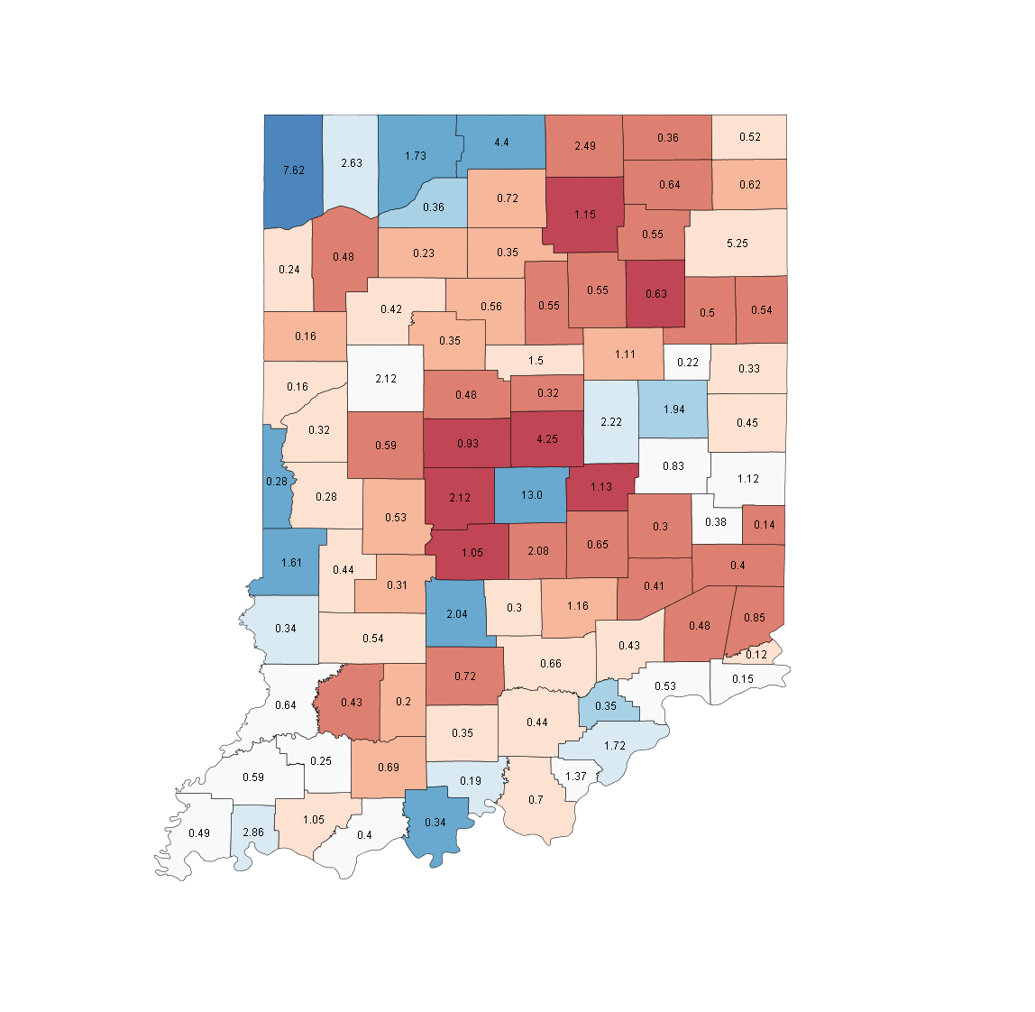
Races (538 Average/SSP Rating): President - Toss-up (O 48.9, M 49.6) Senate - None Governor - Thompson v. Daniels(i) (Likely R) House - IN-09, Hill(i) v. Sodrel (Likely D)
Indiana contains a part of the Chicago metro area in the northeasternmost Lake County, area of heavy scrutiny during the primary, but while this is a very Democratic area, typically 60-40 in a state that give the same margin to the Republican, unlike Illinois, it is nowhere near enough to carry the state. Other areas of Democratic strength are in the west, in Terre Haute, and in Marion County right at the centre of the state, where Indianapolis is. However, Marion is surrounded by a number of deep red counties that didn't give Gore or Kerry even 30%.
This 50-50 result is something that we could definitely be looking at on Election Night, so we should take a close look at swing counties.
Counties to watch: There are three main swing areas in the state, and the difference between winning and losing them is found by comparing the 1996 Presidential and Governor's races at Dave Leip's Atlas.
The first is the southern 'fringe', a range of about a dozen counties with around 15% of the vote in the south of the state. Four of these are clustered together in the southwest, Gibson, Knox, Posey and Pike, the four white counties in the bottom left corner. All four of these were about even with Gore in 2000, but were a few points behind Kerry in 2004, and this represents a big strength area for Evan Bayh. Clinton carried all 4 in '96, but it wasn't enough to take the state. If the bottom edge of Indiana is red on election night, McCain will probably hold, but if it is blue, even if only by a point or two, things will be more interesting.
The second area is to the west centre, the white square labelled '2.12', Tippecanoe County, home to Purdue University. This is generally a dead even county with the overall state numbers, but even losing it didn't hurt Frank O'Bannon in '96. Given Obama's strength with younger voters, this could be a county that a youth surge puts into the blue column and helps shift the state overall.
The final area is the three pale counties gathered together in the East, Fayette, Henry and Wayne. These are generally around a point behind the Presidential candidates in the state, and though they are fairly small, they are fairly solid bellwethers. O'Bannon won two and won the state, Clinton was shut out and lost. While these do look like they have trended away from Democrats just a fraction since then, they should still be close. Painting these blue on the big board may be indicative of a showing that catapults Obama to a GE victory in the state.
Where the people are: As mentioned, the Chicago metropolitan area and suburbs loom large in the northwest, with about a quarter of the state's voters following the northern edge of the state adjacent to Chicago. The largest county, though, is Marion County and Indianapolis, whose core city and suburbs have a further 30% of the vote. Beyond these , the other major areas are Fort Wayne, a slight Republican area in the northeast with ~5% of the vote, and Evansville, a light blue in the southwest 'fringe'.
IOWA
This page includes a map of county names
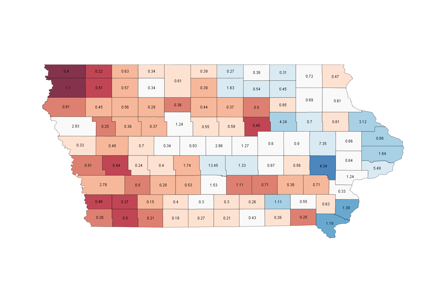
Races (538 Average/SSP Rating): President - Safe Obama (O 54.9, M 43.7) Senate - Safe Democratic (D 61.3, R 36.8 House - IA-04, Greenwald v. Latham(i) (Likely R)
Iowa should be a safe state for Obama this year, but the same was not true in '00 or '04, when it was a near deadlock decided by under 10K votes. So, we basically know what a near 50-50 tie looks like in Iowa, and it's not too different from the map above. It's not anything like a race in Illinois or Indiana, as there are many more swing counties. This is a much paler map than a lot of others, with only a couple of areas of strength for each side.
The western border with Nebraska and North Dakota is a Republican stronghold, including one of the most republican counties in the country, Sioux county, the deep red '1.1' in the northwest corner, which typically votes 85-15 for the Republican. The red is also stronger in the southwest corner, but as we move west, it pales out, and by the eastern part of the state bordering Illinois and Wisconsin, it has turned blue.
Democratic strength lies mostly on the Eastern border with Illinois, clustered around Burlington in the south and Dubuque and Davenport at the 'bulge'. The strongest blue on the map, though, is Iowa City, home to the University of Iowa and an area Obama hopes to build up solid margins in.
Counties to watch: The three white counties around the capital, Des Moines (a pale blue 13.45 in the south-central section) are swing counties that are trending Democratic. Two voted for Kerry and Gore, but only by fairly close margins. If Obama can turn this area strong blue, as I suspect he will, a 10 point state margin is quite possible.
The one competitive House race in IA-04 includes all three of those swing counties, as the district runs along most of the Northern part of the state, but extends down south to nearly surround Polk County, where Des Moines is located. If Becky Greenwald has a chance, she will need to maximize vote thresholds in these swing areas, as well as in the pale blue counties at the north of the state.
Where the people are: More than 20% of votes will come from the Des Moines area, with another 10% on the Iowa-Illinois border from Davenport and Burlington and 11% in the area around Iowa City and Cedar Rapids. Of these, Des Moines is the least Democratic, so a strong win here will help Obama to take the state handily.
KANSAS
This page includes a map of county names
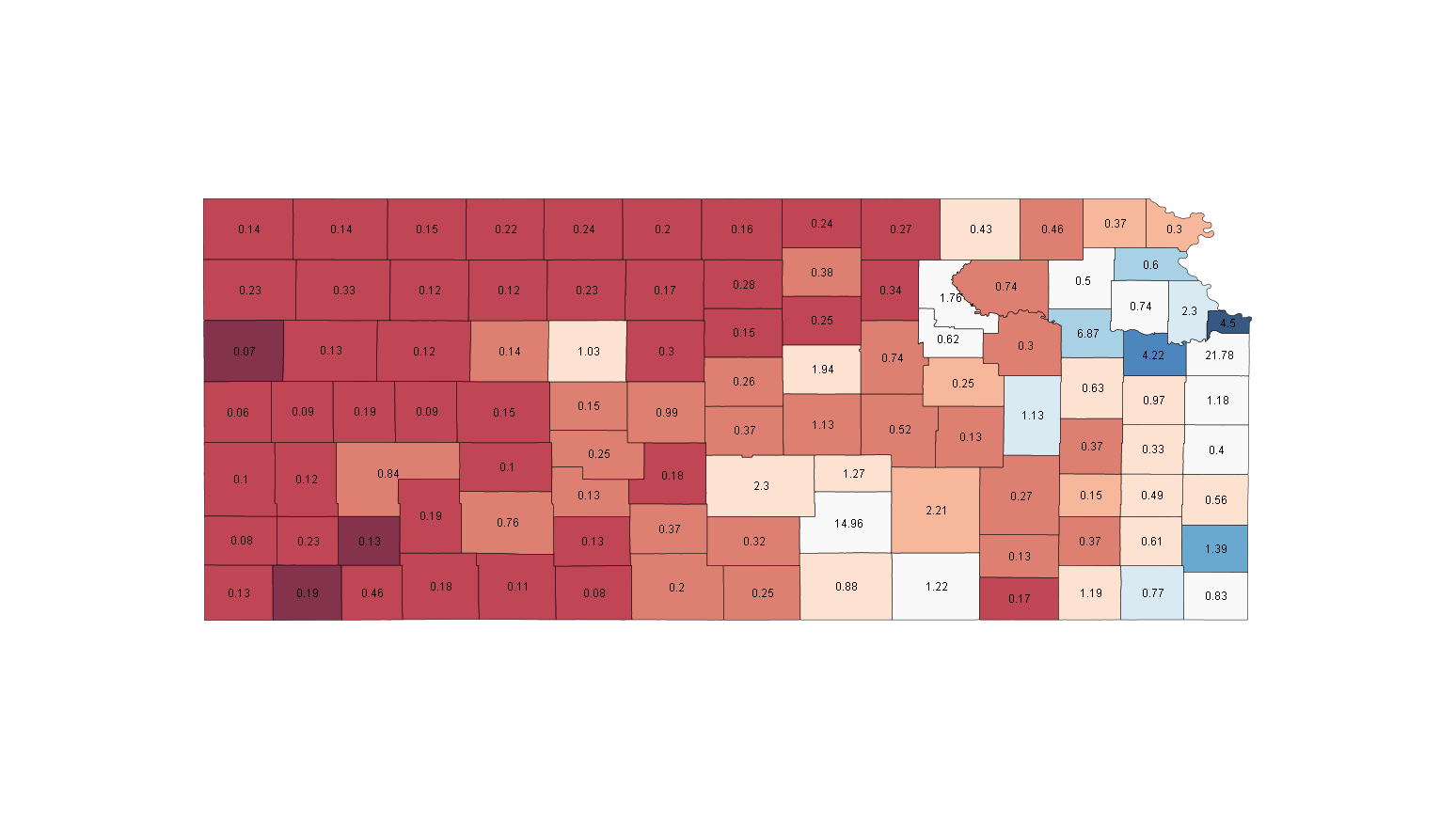
Races (538 Average/SSP Rating): President - Safe McCain (O 41.3, M 57.3) Senate - Safe Republican (D 38.2, R 59.0) House - KS-02, Boyda(i) v. Jenkins (Lean D), KS-03, Moore(i) v. Jordan (Likely D)
Barack Obama has a mother from Kansas, but it won't help his chances in the state, where he is polling well down. Still, don't be too fooled by the map, the many brick red counties across the centre and west of the state are very small, and are almost canceled out by the one 65-35 Democratic county in the state, Wyandotte, in the Kansas City area.
Kathleen Sebelius managed to get elected as a Democrat, but did it by winning a number of those deep red areas that went against Kerry and Gore 25-75. So, for a national Democrat to be elected, Sebelius' model is a tough one to follow. What's really interesting about Kansas is the fact that unlike in many states, the two largest counties are state-average rather than particularly partisan, a big difference from the two states above.
Counties to watch: Sedgwick County, labelled 14.96 in the southern part of the state, contains Wichita, and voted 60-40 for Bush both times, much like the state as a whole. On the Missouri Border, white Johnson county, just south of the deep blue, is fast-growing Kansas City suburbs, and while suburban voters seem to be moving Democratic, it may not be fast enough to allow victory here. If Obama ends up with a 60-40 loss, expect these counties to be at that number. If they look better, chances are his state numbers will too.
The two congressional districts that are close should be Democratic holds, with Nancy Boyda's KS-02 stretching over the entire eastern edge of the state except for the Kansas City area, including Johnson County, which belongs in the also contested KS-03. Boyda will want to build margins in the Kansas City suburbs and Topeka, while Moore will seek to maximize what areas of Kansas City proper there are in his district.
Where the people are: Almost 40% of voters are in the Northeast corner, most in the Kansas City area, but in Topeka and Lawrence as well. This area is the most voter dense in the state. Wichita and the surrounding area are the other main area of people, with more than 20% clustered in the area around Sedgwick County.
KENTUCKY
This page includes a map of county names
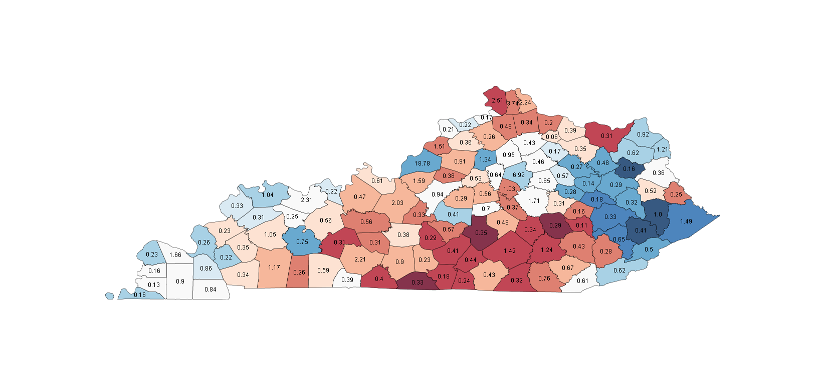
Races (538 Average/SSP Rating): President - Safe McCain (O 42.1, M 56.7) Senate - Lean Republican (D 46.9, R 50.7) House - KY-02, Boswell v. Guthrie (Lean R), KY-03, Yarmouth(i) v. Northup (Likely D)
Bill Clinton showed a Democratic path to winning the state in the 90s, and it remains true today, to 'corner' the Republican votes in the centre, surrounding them by winning the Eastern and Western border areas. This almost worked for Dan Mongiardo against Jim Bunning, and it looks like it might almost work for Bruce Lunsford against Mitch McConnell, as Kentucky has again developed a close senate race.
Kentucky is 29th in area, but 3rd in county number, so most are very, very small. In the western part of the state, there are some deeply Democratic counties, generally around 65-35 for both Kerry and Gore. I expected these to be heavily African-American given that it's rare to see Democratic strength in smaller counties, but they are heavily white instead. I suspect that these are West Virginia-like areas, which are or were heavily based on mining, and retain a strong blue streak even as the rest of the state tends to be more red. The other main Democratic area is Louisville, which is not surprising. Republican counties stretch down the middle of the state, from the brick-red Boone county and the metro area of Cincinnati in the North to wide swaths of red along the border with Tennessee.
Counties to watch: For Lunsford there are two main areas key to winning. First, he has to successfully 'seal in' Republican votes by winning a good chunk of the western tip of the state. This includes the swing county of McCracken, home to Paducah, right on the Illinois border.
The other important area surrounds the area of Lexington, which is itself contained in Fayette County, a pale blue county labeled 6.99 in the state's north-centre. This ring of white counties surrounding Lexington must go blue for Lunsford to have any chance, and preferably by at least a few points, as Mongiardo managed to win several without winning the state.
In the two House races, KY-03 covers Louisville itself, and Yarmouth is looking fairly safe there. KY-02 starts just south of the Louisville, and carries down through some fairly red area nearly to the Tennessee border. The two key areas will be the areas just outside Louisville and the sing county of Daviess on the west of the district (a white 2.31 county). Daviess is home to Owensboro, the third-largest city in the state, so building up margin there and in the Louisville area is key to claim the open seat.
Where the people are: Around 20% are in the Louisville area, another 12-15% are around Lexington and 8% are in the outskirts of Cincinnati. Of these, Lousiville and Cincinnati are relative party strongholds, Democratic and Republican respectively, while Lexington proper tends to be Democratic. but the regions around it are key swing areas, as mentioned.
LOUISIANA
**Note much of this information is pre-Katrina based, so there is a high chance for variability**
This page includes a map of county names
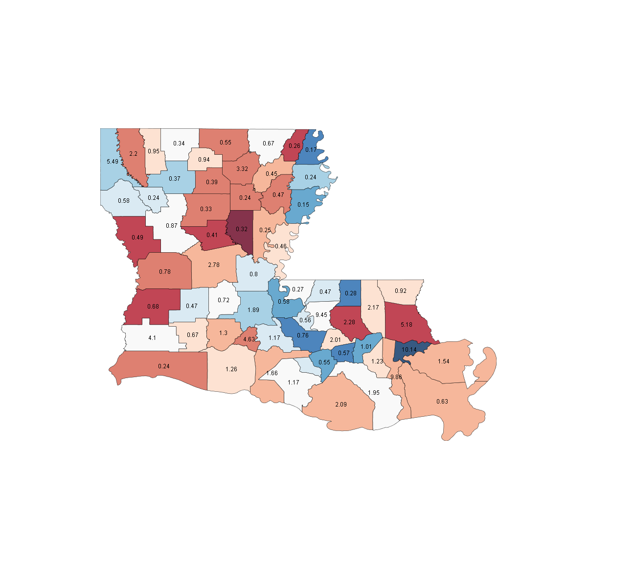
Races (538 Average/SSP Rating): President - Safe McCain (O 43.6, M 55.3) Senate - Safe Democratic (D 56.4, R 41.0) House - LA-01, Harlan v. Scalise(i) (Likely R), LA-04, Carmouche v. Thompson (Tossup), LA-06, Cazayoux(i) v. Cassidy (Tossup), LA-07, Cravins v. Boustany(i) (Likely R)
Ok, I'll keep this one fairly short, since I don't have any data for a one-on-one Democratic-Republican race since Katrina, and the pre-Katrina data is in a very different sort of world. Orleans Parish is still a strong area for Democrats, but based on the 2006 Governor's race, is nowhere near as high a proportion of the vote as in pre-Katrina times. While it looks from that race as though the general trend across the state has held, basically the deep blue areas are probably less blue now, and other areas are a little closer to state average now that they make up a bigger part of the state.
One of the most Republican strongholds in the state is just north of Orleans Parish, St. Tammany Parish. This is a fast-growing area, and if the growth is Democratic voters moving in, you may see this pale, but if not, Democrats could be in for some long years. In 2002, Mary Landrieu did a good job of pushing into some Republican areas, stretching a length of blue counties diagonally from northeast to southwest, and she looks on pace to do the same, as she is safely ahead.
Counties to watch: With no real compelling state-wide races, watch Orleans Parish. This is our first chance to get a sense of how the new Louisiana will play in Presidential politics, and also will give some concrete sense of how New Orleans has changed in the last 4 years.
There are 4 competitive House districts in the state this time around. LA-01 is tough ground, the red areas just north of New Orleans, including St. Tammany Parish. The new growth I mentioned will be key here. LA-04 is the eastern portion of the state, starting in the northeastern corner and stretching almost the entire length of the stat, stopping just short of the white-coloured swing parish of Calcasieu. The key here is in the northeast corner, Caddo Parish, containing Shreveport, which is a source of Democratic votes. The 6th in Don Cazayoux's district, and Swing State Project did a great profile for the special election there. LA-06 is right on the 'elbow' of the state. Livingston is the dark red area, and a Republican stronghold, but the area where the battle was fought and won was Baton Rouge, an area that has grown with many people leaving New Orleans, and the white parish with a 9.45 label. LA-07 is the southwestern corner of the state, and a takeover there would require a good showing in light blue St. Landry Parish just to the west of LA-06, as well as in Lake Charles and Calcasieu Parish.
Where the people are: With New Orleans losing a lot of its population, it has ceded ground to Baton Rouge and Shreveport in the northwest, but the general area around Orleans Parish still has a good chunk of the population. I don't really trust these numbers, we'll get a better idea after Tuesday night.
MAINE
This page includes a map of county names
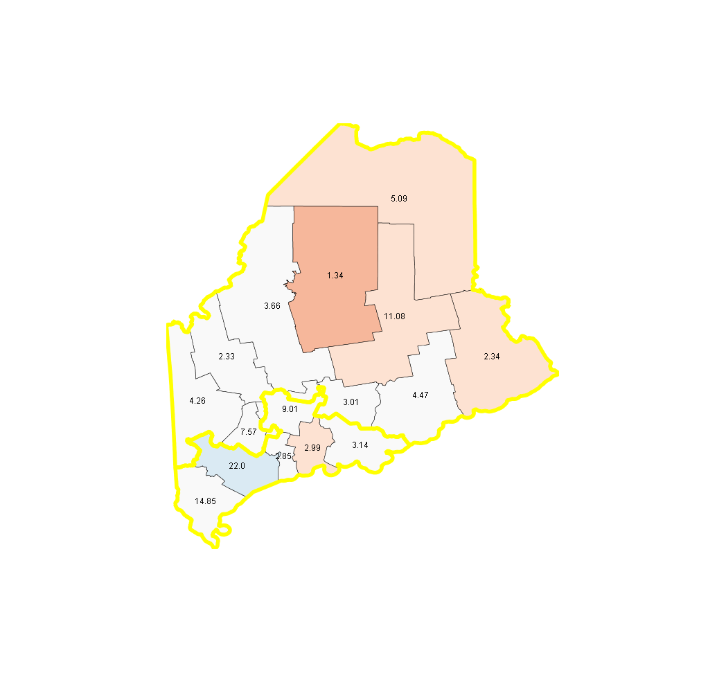
Races (538 Average/SSP Rating): President - Safe Obama (O 55.2, M 42.6) Senate - Safe Republican (D 55.9, R 42.4) House - None close
Maine is one of the overall palest states yet, with no really strong Democratic or Republican areas. Since two electoral votes are given to the CD winners, I have added the district lines to this map. In the entire state, only Piscataquis County, the darkest red, leans more than 5 points from the state average. Cumberland County, the only blue county in the state, contains Portland, but is large and leaning enough to balance the pale red northern counties.
Given that the state as a whole is a 13 point gap in the polling, this map projects a blue Obama sweep, rendering the congressional district fight null and void. However, if McCain could close to within 5-6 points state-wide, an unlikely proposition, the second district, which basically covers the northern half of the state, could be in play. I had high hopes for unseating Susan Collins, but it looks unlikely from the polling.
Counties to watch: With so many counties that go with the overall flow of the state, it's tough to pick out any main swing counties, but I'll highlight a couple.
York County is the southwesternmost in Maine, and contains part of the Portland area. It very closely maps to the statewide average in most races, and it will likely do so again. No Democratic senate candidate has won the county, or the state in 20 years, but Clinton, Gore and Kerry all won it, so to win the state Tom Allen will likely have to take this county, along with at least some of the others around it.
In terms of the ME-02 electoral vote, the place to look to see how viable it is for McCain is Franklin County, the middle white county of the three on the northeastern border. It went 49% to Gore and 55% to Kerry, and if McCain wants the vote he needs to have it closer to the Gore number, so the more Republican areas upstate can put him over the top.
Where the people are: Portland, Lewiston and Augusta are all in the south around the blue district, with the Portland area having more than 1/3 of the vote, and Lewiston and Augusta chipping in with around a third combined as well.
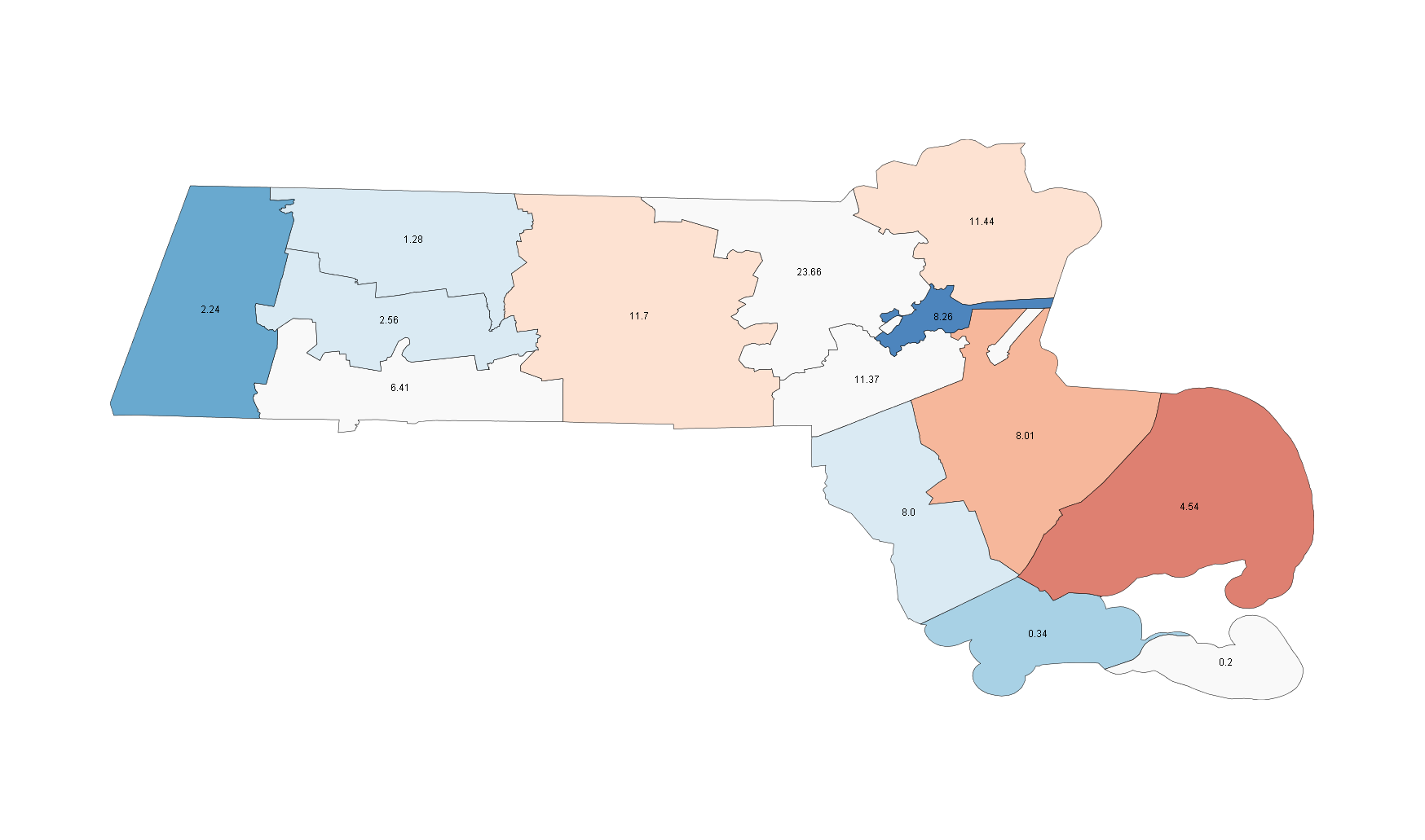
MARYLAND
This page includes a map of county names
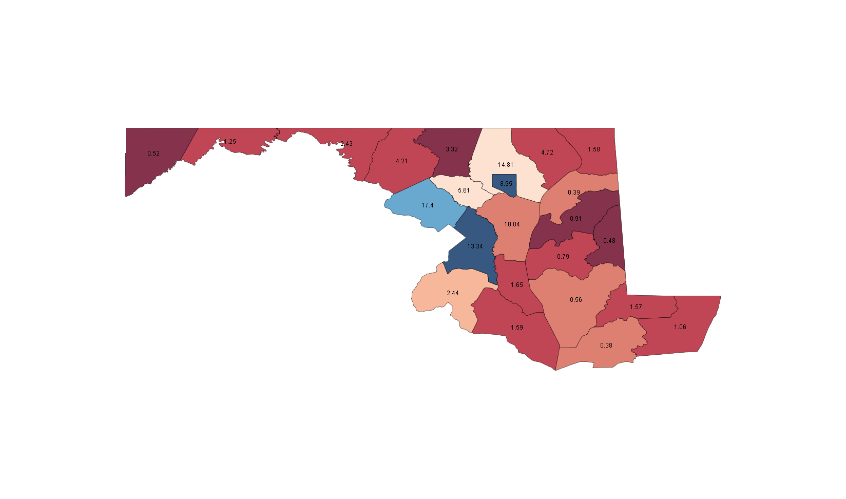
Races (538 Average/SSP Rating): President - Safe Obama (O 62.0, M 37.1) Senate - None House - MD-01, Kratovil v. Harris (Toss-up)
Another one of those states that proves how poor a characterization "blue states" are. John Kerry won the state by 10 points, but lost most of the counties 60-40. This is almost Illinois like, in the sense that you only need to win a few big counties to win the state. Why? Because the city of Baltimore and Prince George's County on the Washington DC border, two heavily African-American areas, deliver their votes to the Democrat by margins of 80-20. Now, if Obama's current polling lead holds, the state will probably be mostly blue on election night, but there are still some Republican areas, including deep red Carroll County just northwest of Baltimore.
Counties to watch: There are no counties in Maryland that fit a swing definition of inside 2 points of the state average, the first state I've done to show that. So watch Baltimore County, the pale red surrounding the blue square of the city proper. If this district looks like a big Obama win, the same will be true state-wide.
Maryland is so absurdly gerrymandered I can hardly make out anything when I overlay the districts, but MD-01 is the western part of the state, including the two deepest red counties, Caroline and Queen Anne's. After a tough Republican primary, nine-term rep Wayne Gilchrist was ousted, and in turn endorsed the Democrat, Frank Kratovil, which may provide a boost in the more moderate counties in the southern and eastern edges of the state. Still, Kratovil is running in double digit Kerry loss territory, so it's a tough haul.
Where the people are: More than 2/3 of the state's voters live in the Baltimore-Washington D.C. corridor, and the massive Democratic strength of these areas is what makes it a Blue state.
MASSACHUSETTS
This page includes a map of county names
*Note that two of these counties are islands (the two blobby one in the southwst), but the census files don't like islands. Heck, the whole coast looks terrible. I don't know why.
Races (538 Average/SSP Rating): President - Safe Obama (O 60.0, M 38.3) Senate - Safe Democratic (D 65.7, R 30.3) House - None Close
Now this is a blue state! The darkest red area on the map, Barnstable County, went to both Gore and Kerry by 10 points, and we can expect a clean sweep of the state from both Kerry and Obama this time around, with the state margin looking like it'll be over 20 points in both races. However, if you look at Mittens Romney's 2002 Gubernatorial win, the pattern is basically the same as what you would see here, with Romney capturing the swing counties and the state. So, some nice validation if nothing else. Overall, a very dull state.
Counties to watch: None, really. Nantucket, an island even though it doesn't look like it on the map, typically maps to the state result pretty well, so it might be a decent predictor of the margin.
Where the people are: The Boston area dominates the state, with more than half the state's voters in the surrounding counties along with Suffolk County and Boston itself.
MICHIGAN
This page includes a map of county names
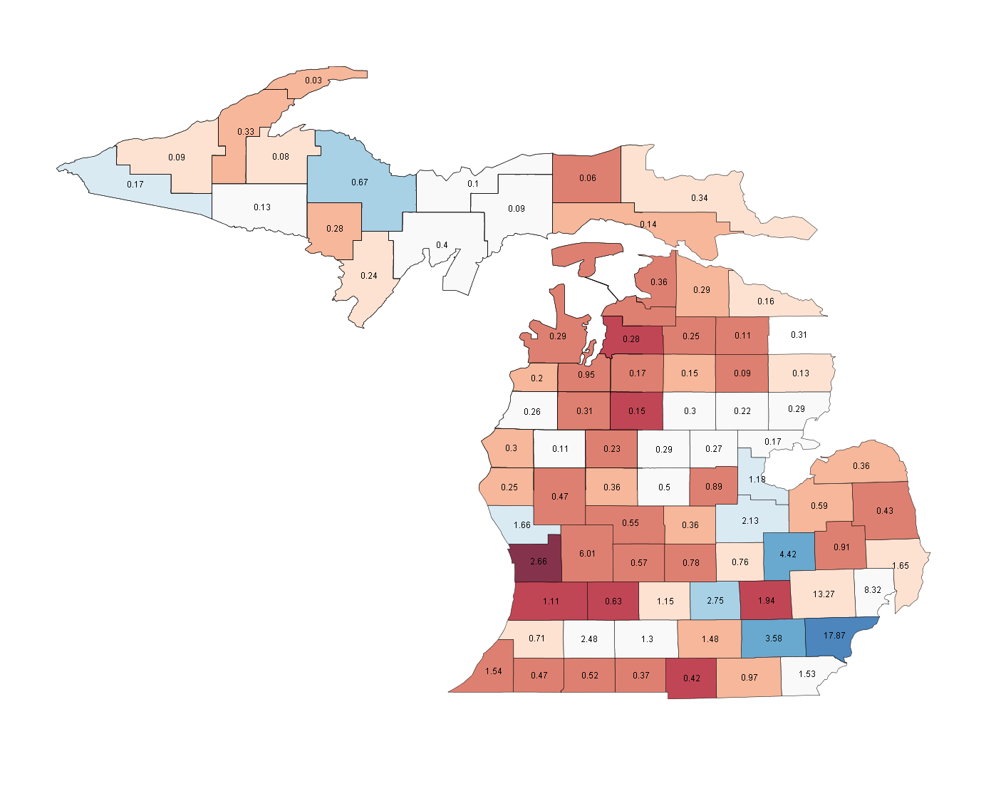
*This is another state that looked messed up in the census files, as the counties technically included the Great Lakes, making the map look absolutely nothing like Michigan. I smoothed out the map, but some islands got lost, and the borders aren't as precise as other maps Still, everything is in the right place generally.
Races (538 Average/SSP Rating): President - Safe Obama (O 54.5, M 43.7) Senate - Safe Democratic (D 62.6, R 34.1) House - MI-07, Schauer v. Wallberg(i) (Tossup), MI-09, Alexander v. Knollenberg(i) (Lean D)
Michigan is a surprisingly balanced state, with many fairly small counties in the middle of the state acting as bellwethers in close races. Of course, there aren't any state-wide close races this time around, so we should expect these to trend Blue, though not by a huge amount. The main Democratic stronghold is, to no one's surprise, Detroit, in the southeast corner of the state. While the surrounding areas are much less blue, Wayne County and Detroit itself typically vote 70-30 for the Democrat. The Republicans have their own Grand response, with Grand Rapids and Kent county being near the heart of their support on the western side of the state.
Counties to watch: State-wide, as I mentioned, watch the cluster of white-coloured counties in the state's centre, including the largest, Isabella County and the coastal counties, Arenac County and Iosco County. I recall reading some speculation that Palin would play well in the upper peninsula, and while it shouldn't matter for the state as a whole, we'll know if that was at all justified by seeing McCain's performance in the swing counties at the centre of the peninsula, which are typically further behind Democratic Presidential candidates than senators.
The two CDs in play are... The 7th, which should have a strong Democratic showing in Washtenaw county, home to the University of Michigan, and directly west of Detroit. The key county here could be the swing county of Calhoun, where a Democratic win combined with a nice margin in Ann Arbor could take the seat. The range of the district is from blue Washtenaw west to Calhoun, the white, with five red counties included in the middle and top of the district.
And the 9th, which is contained entirely within Oakland County, the pale red county just North of Wayne County and Detroit. This is in the Detroit metro area, but not Detroit proper, and is usually a little behind the state average, which in a Democratic year could easily be enough to win.
Where the people are: Detroit, as mentioned above, and Wayne County carry a significant part of the population, and the surrounding counties are some of the largest in the state as well. Altogether, this high-population portion of the southeast has more than 40% of the state's votes.
I'll be back tomorrow with the next ten states.